|
| at: |
Bankhead National Forest |
Data from USFS GIS
 show on map
 animate
Trail users:


Elevation Profile
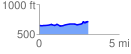
 3.074446 mi
 159.94 ft
 81.95 ft
 78.00 ft
 0.99 %
GPX Downloads: Track Route
![]()
|
| at: |
Bankhead National Forest |
show on map
animate
3.074446 mi
159.94 ft
81.95 ft
78.00 ft
0.99 %