|
| at: |
Bankhead National Forest |
Data from USFS GIS
 show on map
 animate
Trail users:


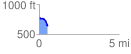
Elevation Profile
 0.532893 mi
 20.55 ft
 146.48 ft
 -125.93 ft
 5.21 %
GPX Downloads: Track Route
![]()
|
| at: |
Bankhead National Forest |
show on map
animate
0.532893 mi
20.55 ft
146.48 ft
-125.93 ft
5.21 %