|
| at: |
Bankhead National Forest |
Data from USFS GIS
 show on map
 animate
Trail users:


Elevation Profile
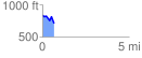
 0.699735 mi
 68.35 ft
 199.98 ft
 -131.64 ft
 5.41 %
GPX Downloads: Track Route
![]()
|
| at: |
Bankhead National Forest |
show on map
animate
0.699735 mi
68.35 ft
199.98 ft
-131.64 ft
5.41 %