|
| at: |
Bankhead National Forest |
Data from USFS GIS
 show on map
 animate
Trail users:


Elevation Profile
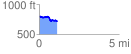
 1.136624 mi
 94.88 ft
 169.69 ft
 -74.81 ft
 2.83 %
GPX Downloads: Track Route
![]()
|
| at: |
Bankhead National Forest |
show on map
animate
1.136624 mi
94.88 ft
169.69 ft
-74.81 ft
2.83 %