|
| at: |
Bankhead National Forest |
Data from USFS GIS
 show on map
 animate
Trail users:


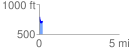
Elevation Profile
 0.206653 mi
 24.44 ft
 97.96 ft
 -73.51 ft
 8.98 %
GPX Downloads: Track Route
![]()
|
| at: |
Bankhead National Forest |
show on map
animate
0.206653 mi
24.44 ft
97.96 ft
-73.51 ft
8.98 %