|
| at: |
Bankhead National Forest |
Data from USFS GIS
 show on map
 animate
Trail users:


Elevation Profile
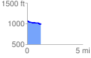
 1.248546 mi
 23.56 ft
 117.92 ft
 -94.36 ft
 1.79 %
GPX Downloads: Track Route
![]()
|
| at: |
Bankhead National Forest |
show on map
animate
1.248546 mi
23.56 ft
117.92 ft
-94.36 ft
1.79 %