|
| at: |
Bankhead National Forest |
Data from USFS GIS
 show on map
 animate
Trail users:


Elevation Profile
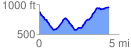
 4.423921 mi
 687.67 ft
 604.72 ft
 82.95 ft
 2.94 %
GPX Downloads: Track Route
![]()
|
| at: |
Bankhead National Forest |
show on map
animate
4.423921 mi
687.67 ft
604.72 ft
82.95 ft
2.94 %