|
| at: |
Bankhead National Forest |
Data from USFS GIS
 show on map
 animate
Trail users:


Elevation Profile
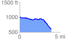
 3.958004 mi
 172.12 ft
 585.88 ft
 -413.75 ft
 2.80 %
GPX Downloads: Track Route
![]()
|
| at: |
Bankhead National Forest |
show on map
animate
3.958004 mi
172.12 ft
585.88 ft
-413.75 ft
2.80 %