|
| at: |
Bankhead National Forest |
Data from USFS GIS
 show on map
 animate
Trail users:


Elevation Profile
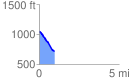
 0.951995 mi
 20.64 ft
 323.03 ft
 -302.39 ft
 6.43 %
GPX Downloads: Track Route
![]()
|
| at: |
Bankhead National Forest |
show on map
animate
0.951995 mi
20.64 ft
323.03 ft
-302.39 ft
6.43 %