|
| at: |
Bankhead National Forest |
Data from USFS GIS
 show on map
 animate
Trail users:


Elevation Profile
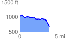
 3.688585 mi
 347.48 ft
 710.26 ft
 -362.78 ft
 3.65 %
GPX Downloads: Track Route
![]()
|
| at: |
Bankhead National Forest |
show on map
animate
3.688585 mi
347.48 ft
710.26 ft
-362.78 ft
3.65 %