|
| at: |
Bankhead National Forest |
Data from USFS GIS
 show on map
 animate
Trail users:


Elevation Profile
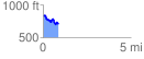
 0.868223 mi
 101.03 ft
 219.87 ft
 -118.85 ft
 4.80 %
GPX Downloads: Track Route
![]()
|
| at: |
Bankhead National Forest |
show on map
animate
0.868223 mi
101.03 ft
219.87 ft
-118.85 ft
4.80 %