|
| at: |
Bankhead National Forest |
Data from USFS GIS
 show on map
 animate
Trail users:


Elevation Profile
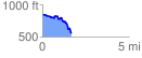
 1.667560 mi
 95.35 ft
 391.10 ft
 -295.74 ft
 4.44 %
GPX Downloads: Track Route
![]()
|
| at: |
Bankhead National Forest |
show on map
animate
1.667560 mi
95.35 ft
391.10 ft
-295.74 ft
4.44 %