|
| at: |
Bankhead National Forest |
Data from USFS GIS
 show on map
 animate
Trail users:


Elevation Profile
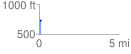
 0.120089 mi
 21.02 ft
 1.16 ft
 19.86 ft
 3.32 %
GPX Downloads: Track Route
![]()
|
| at: |
Bankhead National Forest |
show on map
animate
0.120089 mi
21.02 ft
1.16 ft
19.86 ft
3.32 %