|
| at: |
Bankhead National Forest |
Data from USFS GIS
 show on map
 animate
Trail users:


Elevation Profile
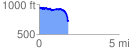
 1.837181 mi
 170.13 ft
 392.63 ft
 -222.50 ft
 4.05 %
GPX Downloads: Track Route
![]()
|
| at: |
Bankhead National Forest |
show on map
animate
1.837181 mi
170.13 ft
392.63 ft
-222.50 ft
4.05 %