|
| at: |
Bankhead National Forest |
Data from USFS GIS
 show on map
 animate
Trail users:


Elevation Profile
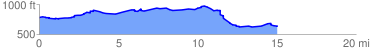
 15.327201 mi
 664.08 ft
 816.83 ft
 -152.75 ft
 1.01 %
GPX Downloads: Track Route
![]()
|
| at: |
Bankhead National Forest |
show on map
animate
15.327201 mi
664.08 ft
816.83 ft
-152.75 ft
1.01 %