|
| at: |
Bankhead National Forest |
Data from USFS GIS
 show on map
 animate
Trail users:


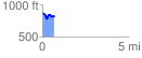
Elevation Profile
 0.684639 mi
 92.05 ft
 149.14 ft
 -57.09 ft
 4.13 %
GPX Downloads: Track Route
![]()
|
| at: |
Bankhead National Forest |
show on map
animate
0.684639 mi
92.05 ft
149.14 ft
-57.09 ft
4.13 %