|
| at: |
Bankhead National Forest |
Data from USFS GIS
 show on map
 animate
Trail users:


Elevation Profile
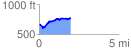
 1.975701 mi
 240.41 ft
 137.58 ft
 102.84 ft
 2.30 %
GPX Downloads: Track Route
![]()
|
| at: |
Bankhead National Forest |
show on map
animate
1.975701 mi
240.41 ft
137.58 ft
102.84 ft
2.30 %