|
| at: |
Bankhead National Forest |
Data from USFS GIS
 show on map
 animate
Trail users:


Elevation Profile
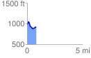
 0.821362 mi
 124.16 ft
 173.62 ft
 -49.46 ft
 4.00 %
GPX Downloads: Track Route
![]()
|
| at: |
Bankhead National Forest |
show on map
animate
0.821362 mi
124.16 ft
173.62 ft
-49.46 ft
4.00 %