|
| at: |
Bankhead National Forest |
Data from USFS GIS
 show on map
 animate
Trail users:


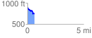
Elevation Profile
 0.618161 mi
 40.90 ft
 194.17 ft
 -153.27 ft
 5.95 %
GPX Downloads: Track Route
![]()
|
| at: |
Bankhead National Forest |
show on map
animate
0.618161 mi
40.90 ft
194.17 ft
-153.27 ft
5.95 %