|
| at: |
Bankhead National Forest |
Data from USFS GIS
 show on map
 animate
Trail users:


Elevation Profile
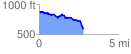
 2.756045 mi
 209.60 ft
 484.38 ft
 -274.78 ft
 3.33 %
GPX Downloads: Track Route
![]()
|
| at: |
Bankhead National Forest |
show on map
animate
2.756045 mi
209.60 ft
484.38 ft
-274.78 ft
3.33 %