|
| at: |
Bankhead National Forest |
Data from USFS GIS
 show on map
 animate
Trail users:


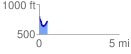
Elevation Profile
 0.544794 mi
 89.07 ft
 170.97 ft
 -81.91 ft
 5.94 %
GPX Downloads: Track Route
![]()
|
| at: |
Bankhead National Forest |
show on map
animate
0.544794 mi
89.07 ft
170.97 ft
-81.91 ft
5.94 %