|
| at: |
Bankhead National Forest |
Data from USFS GIS
 show on map
 animate
Trail users:


Elevation Profile
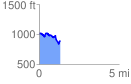
 1.320061 mi
 189.45 ft
 292.33 ft
 -102.88 ft
 4.19 %
GPX Downloads: Track Route
![]()
|
| at: |
Bankhead National Forest |
show on map
animate
1.320061 mi
189.45 ft
292.33 ft
-102.88 ft
4.19 %