|
| at: |
Bankhead National Forest |
Data from USFS GIS
 show on map
 animate
Trail users:


Elevation Profile
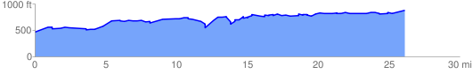
 26.446522 mi
 1800.48 ft
 1357.63 ft
 442.85 ft
 1.29 %
GPX Downloads: Track Route
![]()
|
| at: |
Bankhead National Forest |
show on map
animate
26.446522 mi
1800.48 ft
1357.63 ft
442.85 ft
1.29 %