|
| at: |
Bankhead National Forest |
Data from USFS GIS
 show on map
 animate
Trail users:


Elevation Profile
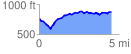
 4.573041 mi
 504.70 ft
 402.33 ft
 102.37 ft
 2.09 %
GPX Downloads: Track Route
![]()
|
| at: |
Bankhead National Forest |
show on map
animate
4.573041 mi
504.70 ft
402.33 ft
102.37 ft
2.09 %