|
| at: |
Blue Ridge WMA Bull/Jake Mountain |
Data from David Muse
 show on map
 animate
Trail users:


Elevation Profile
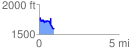
 0.928249 mi
 199.86 ft
 339.83 ft
 -139.97 ft
 6.93 %
GPX Downloads: Track Route
![]()
|
| at: |
Blue Ridge WMA Bull/Jake Mountain |
show on map
animate
0.928249 mi
199.86 ft
339.83 ft
-139.97 ft
6.93 %