|
| at: |
Bankhead National Forest |
Data from USFS GIS
 show on map
 animate
Trail users:


Elevation Profile
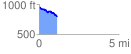
 1.127422 mi
 41.98 ft
 191.41 ft
 -149.43 ft
 3.22 %
GPX Downloads: Track Route
![]()
|
| at: |
Bankhead National Forest |
show on map
animate
1.127422 mi
41.98 ft
191.41 ft
-149.43 ft
3.22 %