|
| at: |
Bankhead National Forest |
Data from USFS GIS
 show on map
 animate
Trail users:


Elevation Profile
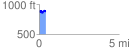
 0.434056 mi
 61.99 ft
 84.92 ft
 -22.94 ft
 3.71 %
GPX Downloads: Track Route
![]()
|
| at: |
Bankhead National Forest |
show on map
animate
0.434056 mi
61.99 ft
84.92 ft
-22.94 ft
3.71 %