|
| at: |
Bankhead National Forest |
Data from USFS GIS
 show on map
 animate
Trail users:


Elevation Profile
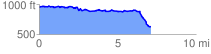
 7.275199 mi
 524.03 ft
 842.59 ft
 -318.57 ft
 2.19 %
GPX Downloads: Track Route
![]()
|
| at: |
Bankhead National Forest |
show on map
animate
7.275199 mi
524.03 ft
842.59 ft
-318.57 ft
2.19 %