|
| at: |
Bankhead National Forest |
Data from USFS GIS
 show on map
 animate
Trail users:


Elevation Profile
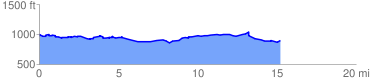
 15.340913 mi
 893.43 ft
 965.33 ft
 -71.90 ft
 1.19 %
GPX Downloads: Track Route
![]()
|
| at: |
Bankhead National Forest |
show on map
animate
15.340913 mi
893.43 ft
965.33 ft
-71.90 ft
1.19 %