|
| at: |
Bankhead National Forest |
Data from USFS GIS
 show on map
 animate
Trail users:


Elevation Profile
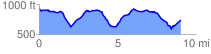
 9.653426 mi
 1122.84 ft
 1205.08 ft
 -82.24 ft
 2.36 %
GPX Downloads: Track Route
![]()
|
| at: |
Bankhead National Forest |
show on map
animate
9.653426 mi
1122.84 ft
1205.08 ft
-82.24 ft
2.36 %