|
| at: |
Bankhead National Forest |
Data from USFS GIS
 show on map
 animate
Trail users:


Elevation Profile
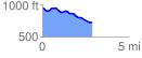
 2.850323 mi
 85.34 ft
 295.83 ft
 -210.49 ft
 1.97 %
GPX Downloads: Track Route
![]()
|
| at: |
Bankhead National Forest |
show on map
animate
2.850323 mi
85.34 ft
295.83 ft
-210.49 ft
1.97 %