|
| at: |
Bankhead National Forest |
Data from USFS GIS
 show on map
 animate
Trail users:


Elevation Profile
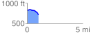
 1.011209 mi
 28.14 ft
 127.18 ft
 -99.04 ft
 2.38 %
GPX Downloads: Track Route
![]()
|
| at: |
Bankhead National Forest |
show on map
animate
1.011209 mi
28.14 ft
127.18 ft
-99.04 ft
2.38 %