|
| at: |
Bankhead National Forest |
Data from USFS GIS
 show on map
 animate
Trail users:


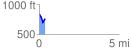
Elevation Profile
 0.361209 mi
 70.30 ft
 144.29 ft
 -73.99 ft
 7.57 %
GPX Downloads: Track Route
![]()
|
| at: |
Bankhead National Forest |
show on map
animate
0.361209 mi
70.30 ft
144.29 ft
-73.99 ft
7.57 %