|
| at: |
Bankhead National Forest |
Data from USFS GIS
 show on map
 animate
Trail users:


Elevation Profile
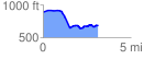
 3.152070 mi
 168.66 ft
 379.80 ft
 -211.14 ft
 2.28 %
GPX Downloads: Track Route
![]()
|
| at: |
Bankhead National Forest |
show on map
animate
3.152070 mi
168.66 ft
379.80 ft
-211.14 ft
2.28 %