|
| at: |
Bankhead National Forest |
Data from USFS GIS
 show on map
 animate
Trail users:


Elevation Profile
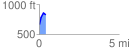
 0.447558 mi
 193.31 ft
 26.91 ft
 166.41 ft
 8.18 %
GPX Downloads: Track Route
![]()
|
| at: |
Bankhead National Forest |
show on map
animate
0.447558 mi
193.31 ft
26.91 ft
166.41 ft
8.18 %