|
| at: |
Bankhead National Forest |
Data from USFS GIS
 show on map
 animate
Trail users:


Elevation Profile
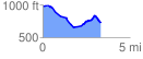
 3.365943 mi
 220.42 ft
 477.66 ft
 -257.24 ft
 2.69 %
GPX Downloads: Track Route
![]()
|
| at: |
Bankhead National Forest |
show on map
animate
3.365943 mi
220.42 ft
477.66 ft
-257.24 ft
2.69 %