|
| at: |
Bankhead National Forest |
Data from USFS GIS
 show on map
 animate
Trail users:


Elevation Profile
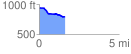
 1.623229 mi
 18.80 ft
 169.50 ft
 -150.71 ft
 1.98 %
GPX Downloads: Track Route
![]()
|
| at: |
Bankhead National Forest |
show on map
animate
1.623229 mi
18.80 ft
169.50 ft
-150.71 ft
1.98 %