|
| at: |
Bankhead National Forest |
Data from USFS GIS
 show on map
 animate
Trail users:


Elevation Profile
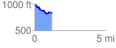
 1.223936 mi
 74.75 ft
 193.30 ft
 -118.55 ft
 2.99 %
GPX Downloads: Track Route
![]()
|
| at: |
Bankhead National Forest |
show on map
animate
1.223936 mi
74.75 ft
193.30 ft
-118.55 ft
2.99 %