|
| at: |
Bankhead National Forest |
Data from USFS GIS
 show on map
 animate
Trail users:


Elevation Profile
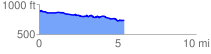
 5.452547 mi
 223.71 ft
 397.78 ft
 -174.07 ft
 1.38 %
GPX Downloads: Track Route
![]()
|
| at: |
Bankhead National Forest |
show on map
animate
5.452547 mi
223.71 ft
397.78 ft
-174.07 ft
1.38 %