|
| at: |
Bankhead National Forest |
Data from USFS GIS
 show on map
 animate
Trail users:


Elevation Profile
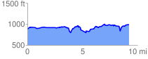
 9.346069 mi
 889.27 ft
 788.75 ft
 100.52 ft
 1.80 %
GPX Downloads: Track Route
![]()
|
| at: |
Bankhead National Forest |
show on map
animate
9.346069 mi
889.27 ft
788.75 ft
100.52 ft
1.80 %