|
| at: |
Bankhead National Forest |
Data from USFS GIS
 show on map
 animate
Trail users:


Elevation Profile
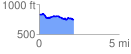
 2.204879 mi
 141.21 ft
 217.95 ft
 -76.74 ft
 1.87 %
GPX Downloads: Track Route
![]()
|
| at: |
Bankhead National Forest |
show on map
animate
2.204879 mi
141.21 ft
217.95 ft
-76.74 ft
1.87 %