|
| at: |
Bankhead National Forest |
Data from USFS GIS
 show on map
 animate
Trail users:


Elevation Profile
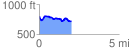
 2.049752 mi
 153.00 ft
 235.34 ft
 -82.34 ft
 2.17 %
GPX Downloads: Track Route
![]()
|
| at: |
Bankhead National Forest |
show on map
animate
2.049752 mi
153.00 ft
235.34 ft
-82.34 ft
2.17 %