|
| at: |
Bankhead National Forest |
Data from USFS GIS
 show on map
 animate
Trail users:


Elevation Profile
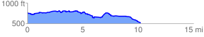
 10.255091 mi
 611.09 ft
 873.68 ft
 -262.59 ft
 1.61 %
GPX Downloads: Track Route
![]()
|
| at: |
Bankhead National Forest |
show on map
animate
10.255091 mi
611.09 ft
873.68 ft
-262.59 ft
1.61 %