|
| at: |
Bankhead National Forest |
Data from USFS GIS
 show on map
 animate
Trail users:


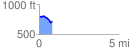
Elevation Profile
 0.800327 mi
 39.94 ft
 116.61 ft
 -76.68 ft
 2.76 %
GPX Downloads: Track Route
![]()
|
| at: |
Bankhead National Forest |
show on map
animate
0.800327 mi
39.94 ft
116.61 ft
-76.68 ft
2.76 %