|
| at: |
Bankhead National Forest |
Data from USFS GIS
 show on map
 animate
Trail users:


Elevation Profile
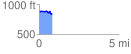
 0.814992 mi
 36.73 ft
 79.31 ft
 -42.59 ft
 1.84 %
GPX Downloads: Track Route
![]()
|
| at: |
Bankhead National Forest |
show on map
animate
0.814992 mi
36.73 ft
79.31 ft
-42.59 ft
1.84 %