|
| at: |
Bankhead National Forest |
Data from USFS GIS
 show on map
 animate
Trail users:


Elevation Profile
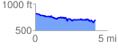
 4.186365 mi
 308.35 ft
 412.01 ft
 -103.66 ft
 1.86 %
GPX Downloads: Track Route
![]()
|
| at: |
Bankhead National Forest |
show on map
animate
4.186365 mi
308.35 ft
412.01 ft
-103.66 ft
1.86 %