|
| at: |
Bankhead National Forest |
Data from USFS GIS
 show on map
 animate
Trail users:


Elevation Profile
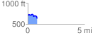
 0.845568 mi
 54.52 ft
 141.70 ft
 -87.18 ft
 3.17 %
GPX Downloads: Track Route
![]()
|
| at: |
Bankhead National Forest |
show on map
animate
0.845568 mi
54.52 ft
141.70 ft
-87.18 ft
3.17 %