|
| at: |
Bankhead National Forest |
Data from USFS GIS
 show on map
 animate
Trail users:


Elevation Profile
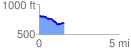
 1.569331 mi
 83.01 ft
 202.50 ft
 -119.48 ft
 2.44 %
GPX Downloads: Track Route
![]()
|
| at: |
Bankhead National Forest |
show on map
animate
1.569331 mi
83.01 ft
202.50 ft
-119.48 ft
2.44 %