|
| at: |
Bankhead National Forest |
Data from USFS GIS
 show on map
 animate
Trail users:


Elevation Profile
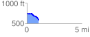
 1.099843 mi
 15.05 ft
 185.50 ft
 -170.46 ft
 3.19 %
GPX Downloads: Track Route
![]()
|
| at: |
Bankhead National Forest |
show on map
animate
1.099843 mi
15.05 ft
185.50 ft
-170.46 ft
3.19 %