|
| at: |
Bankhead National Forest |
Data from USFS GIS
 show on map
 animate
Trail users:


Elevation Profile
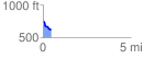
 0.463438 mi
 2.86 ft
 131.33 ft
 -128.48 ft
 5.37 %
GPX Downloads: Track Route
![]()
|
| at: |
Bankhead National Forest |
show on map
animate
0.463438 mi
2.86 ft
131.33 ft
-128.48 ft
5.37 %